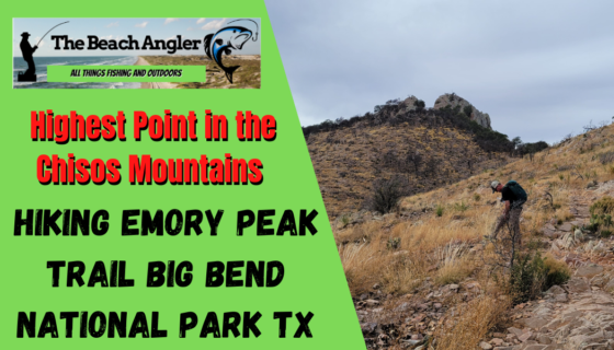
Emory Peak, located in Big Bend National Park, is the highest peak in the Chisos Mountains and the highest in Brewster County. The peak is named for William H. Emory, the chief surveyor of the U.S. Boundary Survey team of 1852. WikipediaElevation: 7,825′
Hunting season is winding down and the weather has been less than ideal for fishing so, it was off Big Bend National Park for some back country hiking.
It’s a great way to get some exercise, fresh air and work off some of those extra pounds that we packed on over the holidays. Hiking Emory Peak in the Big bend National Park offers all that and more.
Not only that, but it was a chance to knock off the rust and give the leg muscles a good work out. They say “if you don’t use it, you lose it” so better try to keep in shape for wading the surf this spring and summer and for hiking the mountains after elk this fall.
Plus, it’s fun and some great scenery. Check out our hike in the South San Juan Wilderness of Colorado. Not only did we get exercise and see some amazing scenery, but we did some pre season scouting for elk season.
Big Bend National Park is several hours drive from anywhere, but the Chisos Mountains, with their lush mixture of juniper and pine forests provide awesome views, rugged back country hiking and, at the higher altitudes, much cooler temperatures providing a welcome relief from the desert heat.
Emory Peak is the highest peak in the Chisos Mountains, at 7825 feet, and from the summit you have spectacular 360 degree panoramic views of the Chisos Mountains and the Chihuahuan desert.
Emory Peak Trail at a Glance:
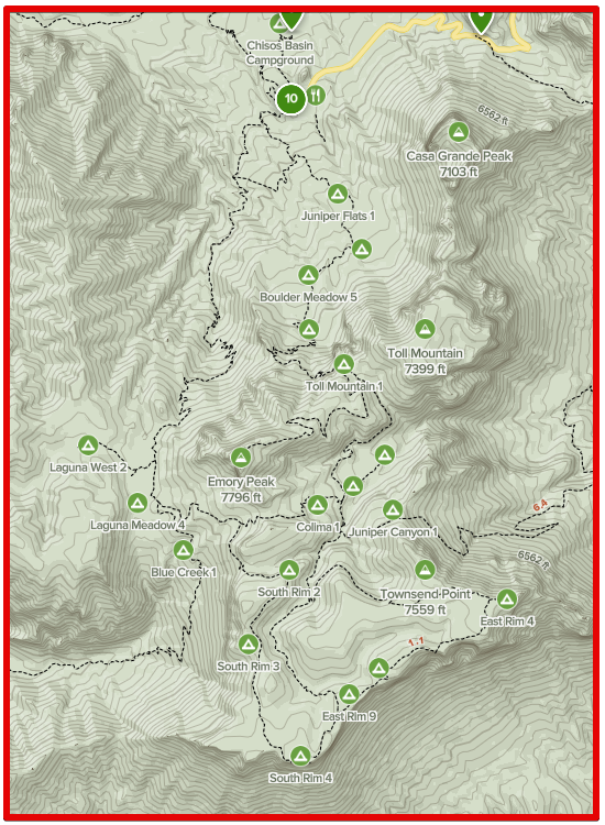
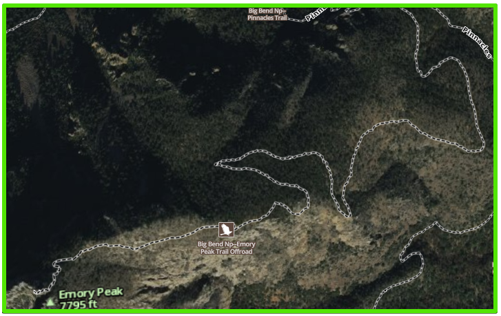
Emory Peak is the highest point in the Chisos Mountains. We chose to travel the Pinnacles trail to the Emory Peak Trail and then on to the summit. This is a strenuous 10.5 mile round trip hike through desert county and up into the Chisos Mountains. You climb about 2500 feet in elevation and the round trip hiking time is between 6 and 8 hours depending on how in shape you are and how much time you want to spend sight seeing along the way. Take plenty of water and snacks. Take your time and never hike alone.
Emory Peak Big Bend National Park Texas
So where, and what exactly, is Big Bend?
The Big Bend is named for the more than 250 mile curve of the Rio Grande river in desert southwest of Texas. The region is rich in natural beauty and history with over one million acres of public land that includes the Big Bend National Park and Big Bend Ranch State Park. These parks offer hiking, camping, canoeing, kayaking and rafting the river, horseback riding, mountain biking, bird watching, and miles of scenic dirt roads.
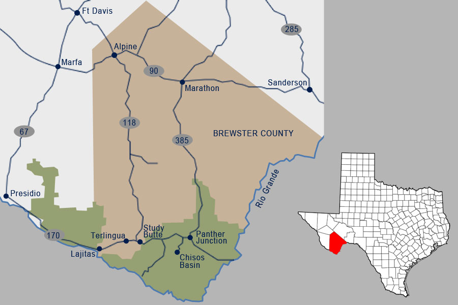
Big Bend is a very sparsely populated area of Texas, but is home to the small communities of Marathon, Study Butte, Terlingua, Lajitas, and Presidio. These communities offer some services, and accommodations as well as a variety of guided outdoor activities. The only way to get to Big Bend is to drive. See the Map below for directions to the area.
Big Bend National Park is the main attraction of the area. It is an 1252 square mile, 800,000-acre national park in southwest Texas along the Texas-Mexico border. It contains three distinct habitats: river, desert, and mountains. Big Bend National Park includes the entire Chisos mountain range and the largest protected area of the Chihuahuan Desert in the United States.
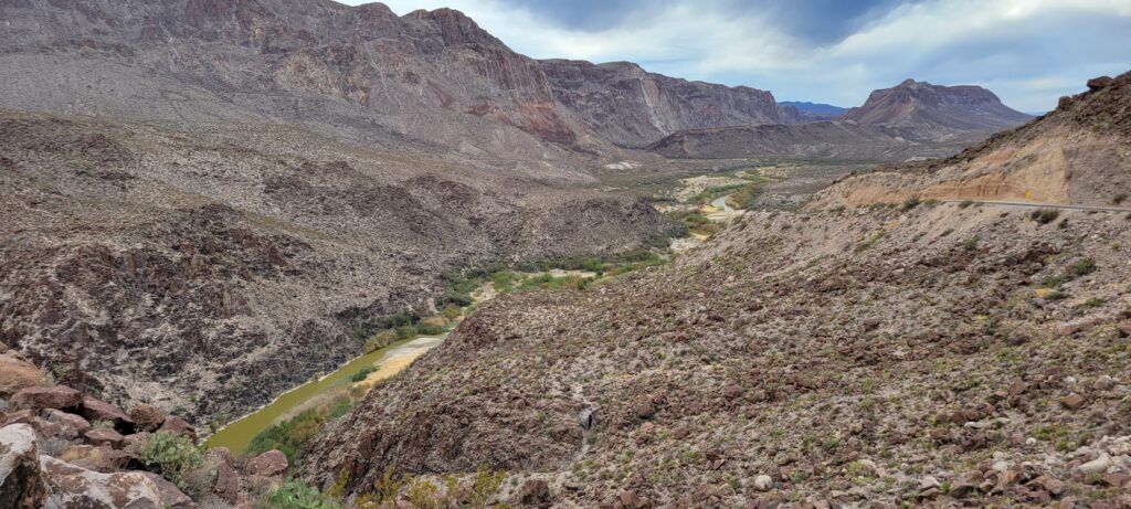
The Rio Grande Wild and Scenic River forms its southern boundary. Big Bend was established as a national park in June 1935. The park is larger than the state of Rhode Island. Big Bend National Park is a very diverse ecosystem with a variety of habitats. From lush vegetation along the banks of the Rio Grande river, to the dry landscape of the Chihuahuan Desert, to the peaks of the Chisos Mountains with grassy meadows and juniper and pine forested hills.
BIG BEND NATIONAL PARK – WEATHER
The weather in Big Bend National Park weather is varied and can change quickly. The Winters are usually mild but snow and sub-freezing temperatures can occur at higher elevations. The Summers are hot and dry as you would expect in the desert. By far, the best times to visit Big Bend are spring and fall with their mild days and cool nights.
ENTRY FEES AND INFORMATION
Big Bend Park is open 24 hours a day, year round. Admission is $20 per vehicle or $10 per individual on motorcycle or bike and is valid for seven days. Annual passes are also available. There is a visitor center and lodge at the Chisos Basin. There you can find all the information and maps for Big Bend National Park.
Big Bend offers plenty of activities for visitors of all ages. The park boasts 150 miles of hiking trails through mountainous desert terrain and along the river. And, on this trip, we were there for the hiking. Specifically hiking up to Emory Peak. But before we tackled the Emory Peak hike, a warm up hike of sorts.
Emory Peak – Warm up on the Window Trail
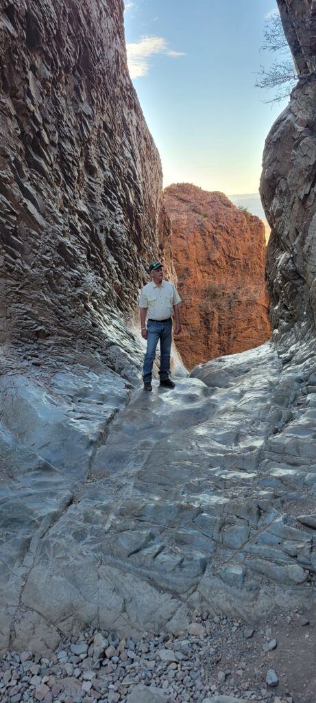
We arrived at the Chisos Basin visitors center mid-afternoon. This was too late in the day to take on the Emory Peak hike, so we opted to warm up if you will, by hiking the Window Trail. This is a moderate to easy hike that served to warm up the leg muscles and get our mountain legs under us for the big hike the next morning.
Window Trail – Big Bend National Park
- Difficulty: Moderate;
- Distance:, 5.6 miles round trip
- Begin at the Chisos Basin Trailhead

The Window Trail is one of the most popular hikes in Big Bend National Park. The trail starts at the Chisos Basin visitor center and follows Oak Creek Canyon along the creek for 2 miles, to where the creek falls off the 220-foot cliff at the western edge of the Chisos Basin. You can usually park at the visitor center parking lot, or at the overflow lot near the campgrounds.

The Window Trail continues right along the stream bed , and during wet conditions, Oak Creek may have water in it. You will be crossing the creek several times during the hike so be prepared for wet feet when the creek is running.
Be very careful, the top of the Window where it drops over the cliff is slick rock with no railings, and its 220 feet to the bottom.
Steps carved into the rock along the path down some minor dry falls help navigate the rocks to the end of the trail at the Window.
The trail is mostly down hill going out with a moderate slope. Of course, that means it’s mostly up hill all the way back. It’s a well-used trail that is good for most hikers.
Take some water, and take you time and enjoy the views of the mountains and the desert floor below from the Window.
Now, It was fairly dark when we arrived back at the visitors center and we needed to gear up and make our plans for the next morning. Destination Emory Peak via the Pinnacles Trail.
To Emory Peak – Tackling the Pinnacles Trail
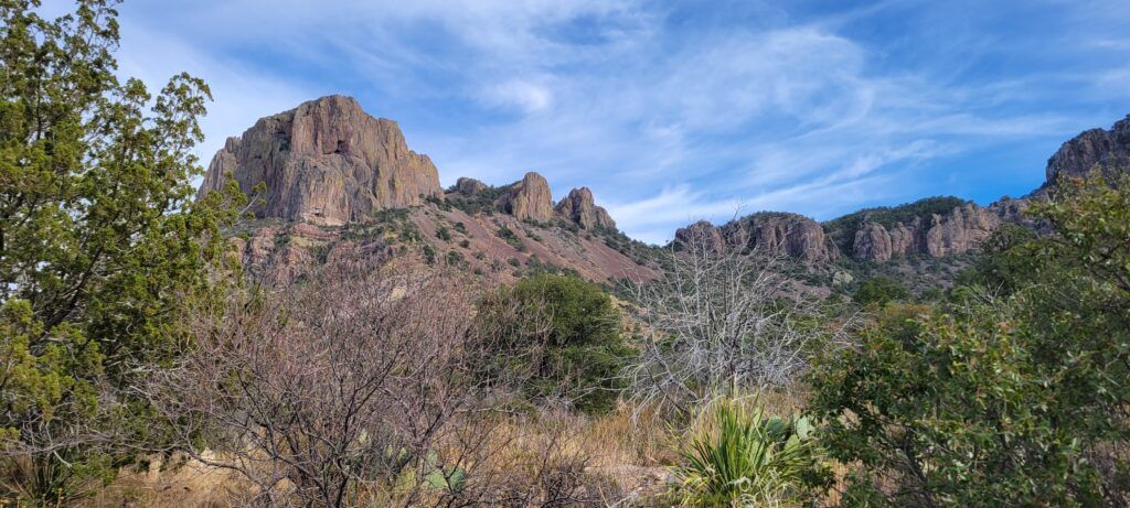
The Pinnacles Trail is the shortest and most direct route to the rim of the Chisos Mountains. But, that means there are some areas of steep climbing and many switchbacks along the way. And, like us, if your destination is Emory Peak, this is the most popular route to get to the Emory Peak trail that leads to the peak.
The journey begins at the west side of the Chisos Basin Visitor Center parking lot. The Pinnacles trail is well-marked with signs that are easy to follow.
The trail takes you up into the higher elevation of the mountains where the air is much cooler, than the visitor center parking lot. There are great views of the surrounding mountains and the basin below as you ascend the trail.
The trail travels up the southwest wall of the Chisos Basin. There are a number of short trails that lead to designated back country campsites along the way. These campsites can be reserved at the visitor center if you care to “rough it”.
We’ve done an overnight in the Chisos Mountains, you can read about that adventure here. The Pinnacles trail is uphill all the way, there are a few relatively “flat” areas on the lower half of the trail before you make the final climb to the rim.
Once you get past the halfway point, the trail really starts to get steep and there are numerous switchbacks as you gain elevation. The trail ends on the Chisos Mountain ridge line at the junction with the Emory Peak Trail.

There is a composting toilet here and two bear boxes where you can store extra gear you don’t need for the last 1.5 mile hike to Emory Peak. You’ll be coming back this way as Emory Peak Trail is one way in and one way out.
Emory Peak Trail – Top of the Chisos Mountains
Once we arrived at the rim and the junction with the Emory Peak trail, we took advantage of the shade of the Junipers to rest and hydrate before making the final hike up to the peak. It is a popular gathering place as the Pinnacles trail connects to the Emory Peak Trail and the Boot Canyon Trail at this point. You will encounter plenty of other hikers during the trip which can be a good thing if you find yourself in need of assistance.
Emory Peak – Big Bend National Park
The highest mountain in Big Bend National Park, reached by well-used trails beginning in Chisos Basin, with an elevation gain of 2500 feet over 3-4 miles.
- Difficulty: Strenuous;
- Distance: 10.5 miles round trip
- Begin at the Chisos Basin Trailhead
- Elevation Change: 2,500 feet
- Average Hiking Time: 6-8 hours
Climb towards the Peak
We started out early in the morning before sunrise and ascended the Pinnacles trail for 3.5 miles to the Emory Peak trail junction. Much of the 2,420 foot climb is along the wooded, north-facing slopes, so the trail is in shadow most of the morning, and sheltered from the wind by the cliffs and mountains. So, it can be a cool climb during fall and winter, bring a light jacket and gloves. Bring plenty of water, snacks and lunch. Emory Peak makes for an awesome backdrop for a high altitude lunch break.
Once you top out on the rim you will take the 1.5-mile Emory Peak trail to the peak. There are some great views along the trail and you can get some awesome photos.
The last quarter mile or so starts to get steep and very rocky, and the last 25 feet you will be climbing straight up a rock face to the peak. There are several routes to the top, but they are all climbing rocks with no room for error.
Emory Peak, the highest point in the park and the west face of Peak is a sheer drop to the desert floor below. Be careful, there are no hand rails. Falling is not so bad, its that sudden stop that hurts. 😉 When you get to the top, you are greeted by some radio antennas and solar panels that are part of Big Bend National Park’s two-way radio system. Go figure, technology is everywhere.
From the summit of Emory Peak you have a 360 degree view of the expansive Chihuahuan desert, all of the Chisos Basin and the surrounding mountains and even into Mexico. Take lots of pictures and enjoy the view. Take a break, have lunch and re hydrate for the climb back down. After lunch and relaxing, then you can choose you next path. Either back the way you came, or choose to take a more indirect path back to the visitor center via one of the other trails along the rim.
Watch for Wildlife mule deer, ground squirrels and a variety of birds are common along the hike. The Chisos mountains are also home to black bears and mountain lions and several encounters are reported every year. We didn’t see either on this trip, but we have seen black bears along the trail on previous hikes and other hikers reported seeing one the day before our hike.

Emory Peak Trail in Short:
The hike to the top of Emory Peak involves a steep climb of about 2,500 feet along a dirt and rock trail. The last 25 feet requires a climb up solid rock without rope or hand rails. Take your time, it’s not a race and never hike alone. If you are unsure, don’t attempt it. There are many other hikes in Big Bend National Park that can be just as enjoyable if you are not up for one this strenuous.
Frequently Asked Questions About the Emory Peak Trail

How long is the Emory Peak Trail?
The Emory Peak Trail is approximately 4.5 miles long (one way) and is considered a strenuous hike.
What is the elevation gain on the Emory Peak Trail?
The trail has an elevation gain of around 2,400 feet, making it a challenging ascent to Emory Peak, the highest point in Big Bend National Park.
How long does it take to hike to the summit of Emory Peak?
The hike to the summit typically takes about 4 to 6 hours, depending on individual hiking speed and trail conditions.
Is a permit required to hike the Emory Peak Trail?
No permit is required specifically for day hiking the Emory Peak Trail. However, an entrance fee is required for entry into Big Bend National Park.
Are there water sources along the Emory Peak Trail?
There are no reliable water sources along the trail, so hikers should carry an adequate supply of water. It’s recommended to bring at least one gallon of water per person.
Are there restrooms along the trail?
There are no restrooms along the trail. Visitors should use restroom facilities at the Chisos Basin Visitor Center before starting the hike.
What is the best time of year to hike the Emory Peak Trail?
The best times to hike are during the cooler months, from fall to spring. Summers can be extremely hot, and temperatures on the trail can reach high levels.
Are dogs allowed on the Emory Peak Trail?
No, pets are not allowed on the trail. This is to protect the park’s wildlife and ensure the safety of both pets and native animals.
Is the Emory Peak Trail well-marked?
The trail is generally well-marked, but hikers should pay attention to trail markers and follow the signs. It’s recommended to carry a map and familiarize yourself with the trail beforehand.
Can I hike to Emory Peak as a day trip, or are camping options available?
The Emory Peak Trail can be hiked as a day trip, and there are also camping options in the Chisos Basin Campground for those interested in overnight stays.
Are there any safety considerations for hiking Emory Peak?
Hikers should be prepared for changes in weather, carry sufficient water, wear sturdy footwear, and be aware of their physical condition due to the strenuous nature of the trail.
Always check current trail conditions and park regulations before embarking on the hike.
Hiking Big Bend: Hikes for all Skill Levels
No matter if you’re just getting into hiking or a veteran hiker, Big Bend National Park has a hike for you. From hike in the desert lowlands to back country hikes and camping in the Chisos Mountains, there really is something for everyone.
It is a desert, so water will be an important commodity. Always take extra, and then take some more.
It won’t go bad and its much better to have it and not need it, than to need it and not have it. Summer can get brutally hot, so fall through spring are you best bets for planning you hiking adventures in the Big Bend.
Load up the family and spend some time together in the great outdoors. You’ll be making memories that will last a lifetime.

As always, stay safe, enjoy the journey and please try to leave it cleaner than you found it. If you have any comments, questions, ideas or suggestions please leave them in the comment section below and I’ll get back to you asap. You can follow us on Facebook: Rex The Beach Angler, Instagram: thebeachangler7, Twitter: @AnglerBeach, and YouTube: Man Art Creations.

A life long surf fisherman with 50+ years of experience, I am also an avid hunter and outdoorsman. I will be sharing my passion for the outdoors with you so be prepared for hunting, fishing, camping, hiking and more. Along with gear reviews and the latest trends and innovations in the outdoor industry.

